| |
|
|
|
|
|
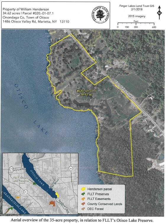
Significant stretches of undeveloped lakeshore are rare in the Finger Lakes and this resource is recognized as a priority for protection in New York State’s Open Space Plan. The 35-acre Otisco Lake Shoreline Protection Project is located at the very south end of the lake, the property features forested wetlands, as well as shallow man-made ponds and open meadows with scattered shade trees. The la. . . read more!
|
|
| |
|
|
|
|
|
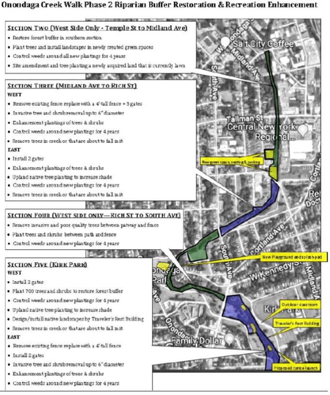
The goal of this project is to aggressively and diligently establish native trees and shrubs over a five year period along the riparian corridor of Onondaga Creek through a combination of invasive species removal, dense planting and consistent weeding. Youth and young adults will lead the way in this effort through the programmatic leadership and expertise of Onondaga Earth Corps, an organization . . . read more!
|
|
| |
|
|
|
|
|
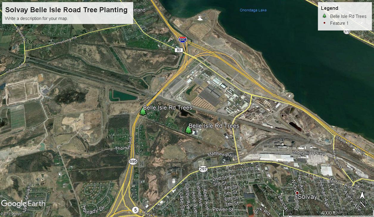
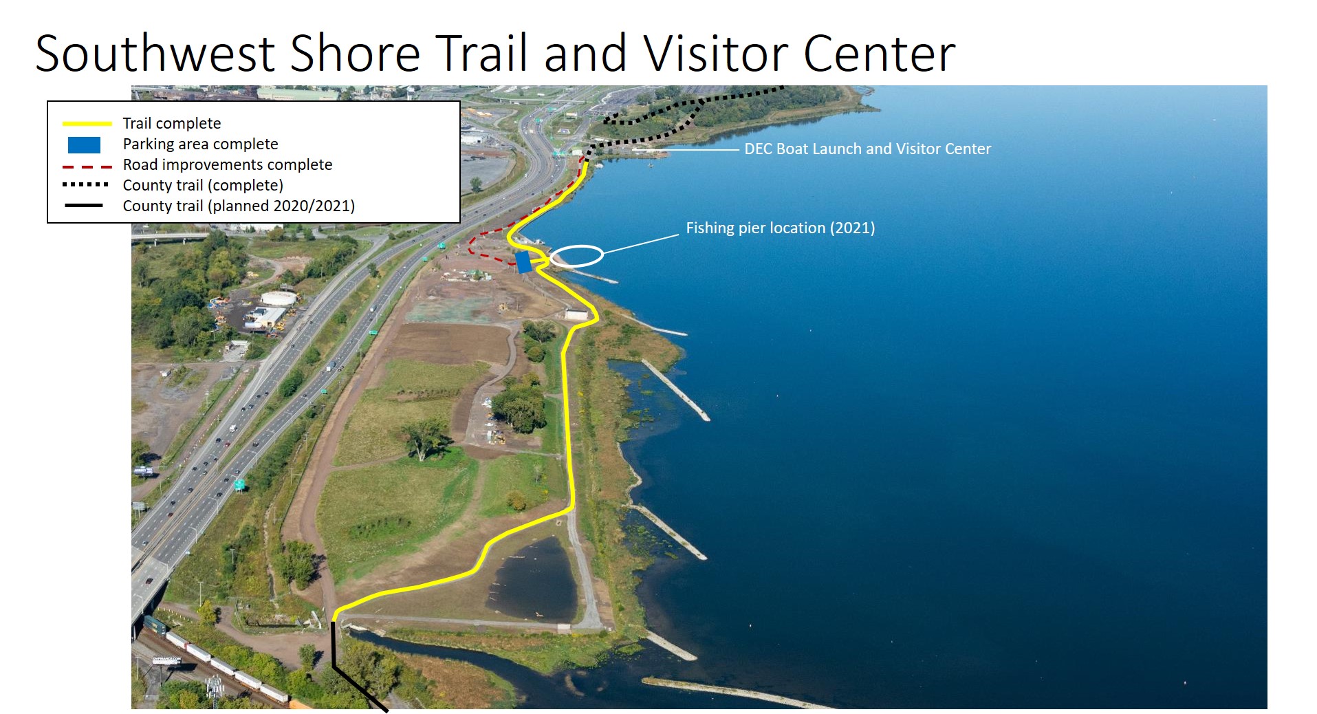
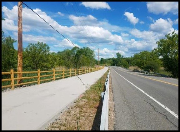
The Erie Canal and Southwest Lakeshore Trail System, within the Village of Solvay, is being conducted by Honeywell as part of the NRDAR Consent Decree. The project will build a new 3.2-mile trail connecting the Old Erie Canal Trail, to the existing Onondaga County Trail. The project includes, preserving Gere Lock 15 as a historical site and constructing a trail on Honeywell property parallel to Ge. . . read more!
|
|
| |
|
|
|
|
|
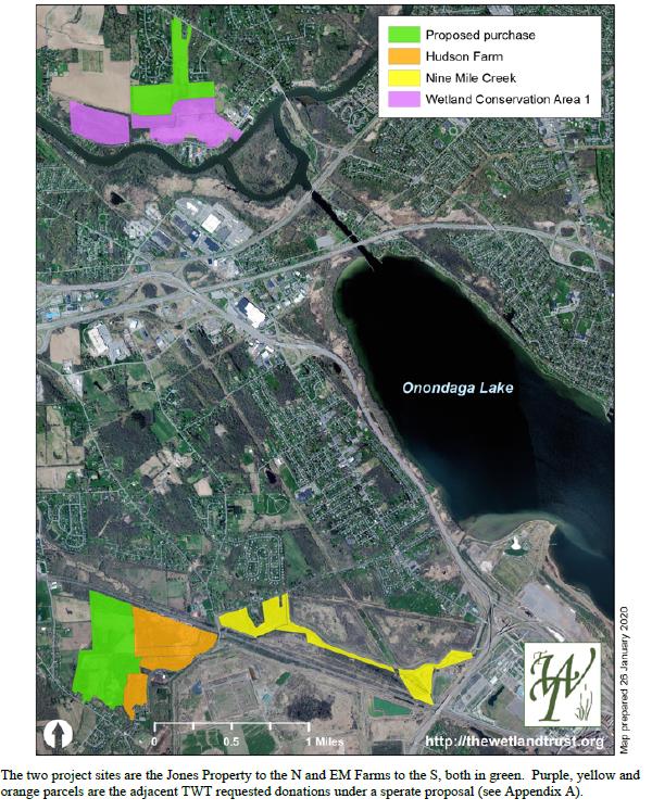
The selected acquisition sites within the Wetland Habitat Restoration on Lands within the Onondaga Lake Basin project are adjacent to parcels previously acquired by the Onondaga Lake Trustees, as described in the March 2018 Onondaga Lake Natural Resources Damage Consent Decree. The project maximizes wetland and forested habitat environmental functionality. This project addresses the need to rest. . . read more!
|
|
| |
|
|
|
|
|
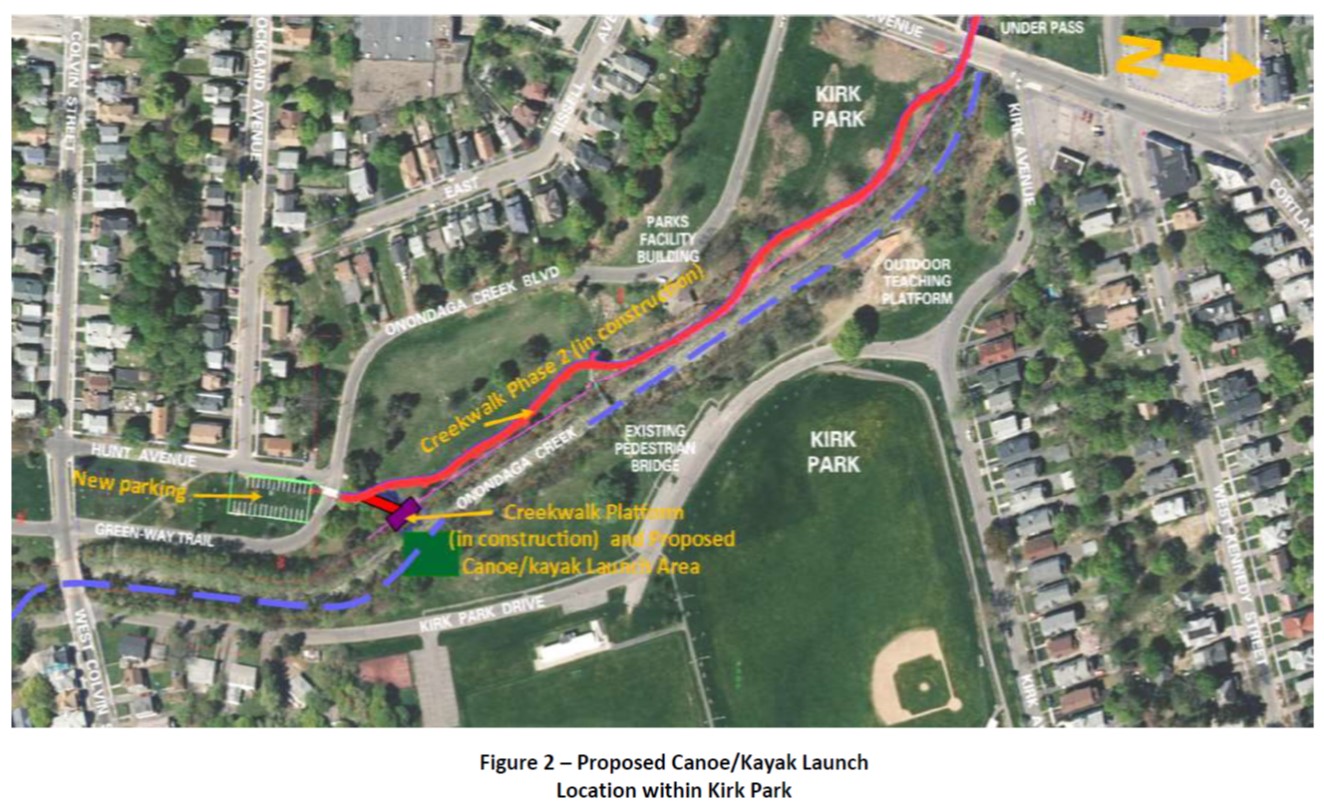
The City of Syracuse will construct a canoe/kayak launch on the west side of Onondaga Creek at Kirk Park and to improve creek navigability through removal of downed and impediment trees. Within the City, Onondaga Creek has no designated canoe/kayak launch sites, and few areas provide suitable access for fishing. This project will provide needed natural resource recreational benefits to Syracuse . . . read more!
|
|
| |
|
|
|
|
|
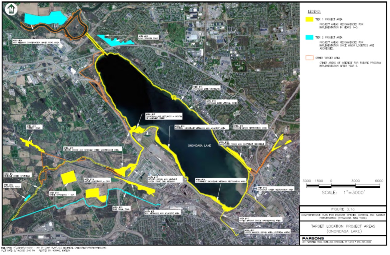
The March 2018 “Onondaga Lake Natural Resource Damage Assessment Consent Decree” and “Appendix C - Onondaga Lake Watershed Restoration Projects Scopes of Work” (Consent Decree), describe the funding for an invasive species control and habitat preservation project. According to the March 2018 Scope of Work for Project 9, The “Invasive Species Control and Habitat Preservation Project” shall be imple. . . read more!
|
|
| |
|
|
|
|
|
In March 2018, the United States Department of the Interior, acting through the United States Fish and Wildlife Service (Service) and the State of New York, acting through the New York State Department of Environmental Conservation (NYSDEC), together the Trustees, settled a natural resource damage claim with the Responsible Parties, Honeywell International Inc. and Onondaga County, New York, for t. . . read more!
|
|
| |

|
|
|
|
|
Old Place Creek is a tributary of the Arthur Kill in the northwestern corner of Staten Island, NY. In 1990, the creek was heavily impacted by the Exxon Bayway and B.T. Nautilus oil spills. The tidal wetlands were particularly hit hard with the destruction of over 8-hectares of salt marshes. This impacted the critical foraging habitats for the "Harbor Herons", wading birds such as great egrets, sno. . . read more!
|
|
| |

|
|
|
|
|
Before extensive development began in Brooklyn, NY during the 1820s, salt marshes extended from Coney Island to what is now 86th Street. Located north of Coney Island Creek, Dreier Offerman Park first opened in 1933. It had been expanded several times, including during the 1960s with the acquisition of 72 acres of land filled with debris excavated during the construction of the Verrazzano-Narrows . . . read more!
|
|
| |

|
|
|
|
|
Goethals Pond is a 50-acre freshwater-to-brackish pond located between the Staten Island Expressway (Interstate-278) and Arlington Yard in the northwestern corner of Staten Island, NY. Originally a tidal salt marsh, Goethals Pond formed after the construction of adjacent roads and railroads greatly reduced tidal flow from Bridge Creek, a tributary of the Arthur Kill. The shallow water and islan. . . read more!
|
|
| |

|
|
|
|
|
Prall's Island is an 89-acre island in the Arthur Kill between Linden, NJ and Staten Island, NY. Originally known as Dongan’s (and later Duncan's) Island, the island became a major agricultural center in the 1800s when the marshes were diked to farm salt hay. During the 1930s, dredge spoils from the Arthur Kill Channel were deposited on Prall's Island, expanding it to its current size. Between Wor. . . read more!
|
|
| |

|
|
|
|
|
The Saw Mill Creek Marsh Preserve is a 182-acre complex of tidal salt marshes, coastal hummocks, and maritime oak forests in western Staten Island, NY. It contains the largest expanse of salt marsh along the eastern shore of the Arthur Kill, providing critical breeding habitat for saltmarsh sparrows, wintering habitat for short-eared owls and northern harriers, and foraging habitat for the "Harbor. . . read more!
|
|
| |
|
|
|
|
|
Salt marshes are highly productive coastal wetlands that provide a variety of ecosystem services. The marshes along the Arthur Kill in northwestern Staten Island are important foraging areas for migratory shorebirds, waterfowl, and wading birds, including the "Harbor Herons" that nest on islands in the NY-NJ Harbor Estuary. Marsh vegetation also helps protect the shoreline from erosion by dissipat. . . read more!
|
|
| |

|
|
|
|
|
Bridge Creek is a tributary of the Arthur Kill in northwestern Staten Island, NY. Tidal salt marshes were historically prevalent along Bridge Creek until the 1950s when the creek was channelized and large portions of the marshes were filled in for industrial development. The headwaters of the creek arise in Goethals Pond. Formerly a salt marsh, the pond formed after the construction of a railroad . . . read more!
|
|
| |

|
|
|
|
|
Mariners Marsh is a 107 acre complex of freshwater emergent wetlands and pine/oak swamp in the Howland Hook (Port Ivory) section of Staten Island, NY. It is hydrologically connected to Newark Bay through Arlington Marsh. Mariners Marsh was used as an industrial property in the early 1900s. The Milliken Brothers Structural Iron Works and Rolling Mill operated on the site from 1903 until 1917, and t. . . read more!
|
|
| |

|
|
|
|
|
In 1991, the Natural Resource Trustees for the Exxon Bayway oil spill transferred $62,960.46 to the Manomet Bird Observatory (MBO) to fund one year of avian studies in the NY-NJ Harbor Estuary. Since the mid-1980s, MBO collected data on bird communities for their New York Harbor Project, including information on avian prey populations (fish and macroinvertebrates), foraging behaviors (strike rates. . . read more!
|
|
| |

|
|
|
|
|
Although a vast amount of geospatial data from the NY-NJ Harbor Estuary existed before the 1990s, a majority of the information only existed in paper form. In the event of an oil or chemical spill, this information was not readily accessible to response personnel. A centralized repository of up-to-date information was needed for timely, informed response during emergency situations.
Utilizing . . . read more!
|
|